Mileage
Notes
![]()
Trail North

Trail
Map
Bay Area Parks
![]()
Bay Area Rec & Travel
![]()
Bay Area Back Pages
![]()
Bay Area Biking
![]()
Bay Trail
![]()
Feedback
Hellyer Park to Anderson Lake Park
Santa Clara County Parks Trail

Coyote Creek Bike path, bridge over Coyote Creek near Parkway Lake, San Jose
![]()
Note: These are new Web pages based on my
old Coyote Creek Trail page. This has been migrated from
www.geocities.com/bayareaparks.
Coyote Creek
Coyote Creek Trail Description
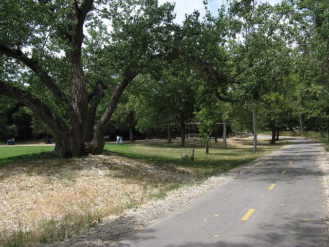
Coyote Creek Trail at the north end of Hellyer County Park
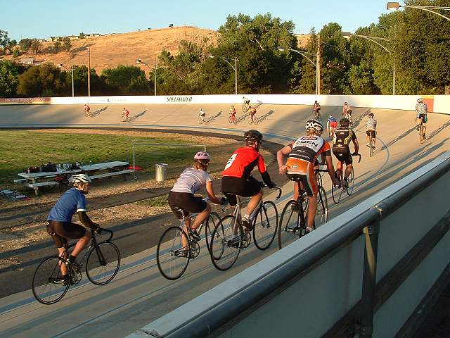
Hellyer Park Velodrome
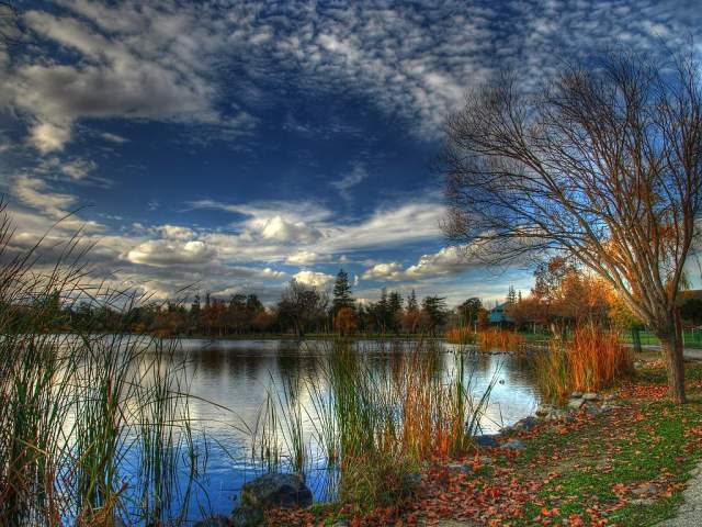
Cottonwood Lake, Hellyer County Park

Coyote Creek Trail approaching the Hwy 101 under-crossing
Leaving Hellyer Park, the trail goes
under Hwy
101 and passes by a disc
golf
course run by the Silicon
Valley Disc Golf Club. It runs at the base of the hill at creek
level. Parts of the creek can be seen right next to the trail. This
part may flood in high water. Where the trail
runs close to creek-level, the
high
water table has caused the tree roots to form speed bumps in the trail.
These natural speed bumps can be found at several stretches along the
trail. Then trail then turns and goes up a
short
rise to run higher above the creek. It runs through a deeply-shaded
segment
along
the backyards of some of the southernnmost high-tech companies in the
Silicon
Valley. This is the Edenvale Technology Park area, where new industrial
buildings have been
popping
up like wildflowers. Along the trail is a huge concrete building that
was once a manufacturing facility. It is now the home of the Silver Creek Sportsplex,
which is "the largest fitness and indoor sports facility under one roof
in North America." A bridge over the creek leads to Shady
Oaks Park, a San Jose city park with picnic areas, playing
fields,
playgrounds, and an abandoned orchard, on Coyote Road. On Silver Creek
Valley Road is a staging area for the Coyote Creek Trail. It has a
gravel parking lot, restrooms, and drinking fountains. At Silver Creek Valley Road, you can depart from the
trail
and take the road up the hill, passing through the exclusive Silver
Creek
development and enter the Evergreen Valley, where the Silver
Creek Valley Trail is being built. The
trail passes under Silver Creek
Valley
Road and crosses over the creek on an old bridge.
Continuing
south, the Coyote Creek Trail passes by some old fruit orchards and
eucalyptus-lined
percolation ponds.

Trail below Hellyer
Ave., east of 101

Coyote
Creek
Trail by poppy-covered hill in the Edenvale Technology Park

Bridge to Shady Oaks Park

Silver Creek Valley Road bridge under-crossing

Coyote Creek
and Trail south of Silver Creek Valley Road

Trail next to Hwy 101 between Silver Creek Valley Road and Enzo Drive

Coyote Creek
Trail by old field north of Enzo Drive

Silicon Valley Blvd. bridge under-crossing
At Silicon Valley Blvd., the trail passes
behind the Holiday
Inn, which has a restaurant if you're hungry and not too dusty. For
fast food, go west on Bernal Road to the shopping centers near Santa
Teresa
Blvd., but be careful of the gauntlet of freeway on and off-ramps. If
you
continue west on Bernal Road, you'll enter Santa
Teresa County Park. A bridge over Coyote Creek at Silicon Valley
Blvd.
leads east and south to the Basking
Ridge neighborhood. A multi-use paved nature trail parallels
the road there for 0.7 miles. Below it is a short equestrian trail.

Basking
Ridge Trail
South of Silicon Valley Blvd., the Coyote Creek Trail ducks under Hwy 85 and 101, and passes by new subdivisions. It skirts Metcalf Park, a San Jose city park, which has lawns, a playground, basketball courts, picnic tables, restrooms, and drinking fountains, making it a good place for a rest stop. The trail continues alongside a series of percolation ponds, including one used for water-skiing by the Santa Clara County Water Ski Club. A wide gravel path, which parallels the paved trail, runs on top of a levee by the percolation ponds. The trail then crosses over Coyote Creek near the privately-run Parkway Lake. Parkway Lake is an excellent fishing spot, where no state fishing license is required. It's heavily planted with trout in the winter, catfish in the summer, and a few large sturgeon.

Metcalf Park, where the gravel levee trail splits from the park's paved trail

Trail south of Metcalf Park, next to Forsum Road

Percolation pond next to Monterey Road between Metcalf Park and Metcalf Road

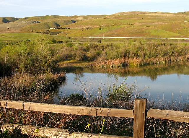
Bridge over Coyote Creek by Parkway Lakes
Near Parkway Lake, the Coyote Creek Trail runs along the edge of Monterey Road. Here is the Coyote Narrows, where the Santa Teresa Hills and the east foothills converge. West of Monterey Road is Tulare Hill, which sits like a cork in the bottle of the Coyote Narrows. North of it is the highly urbanized Silicon Valley. South of it is the rural Coyote Valley. Grass-covered, nearly treeless Tulare Hill is cloaked in wildflowers in the spring. On its southeast corner, is Calpine's huge 600-megawatt Metcalf Energy Center. The towers of the power plant can be seen through the trees on the trail. South of Tulare Hill is the site of the Coyote Valley Research Park. Plans have been made to develop the Coyote Valley, starting here, but they are currently on-hold. On the north side of Tulare Hill, the Coyote-Alamitos Canal levee ends. The levee is a proposed route for the Coyote-Alamitos Canal Trail leading along the Santa Teresa Hills to the Alamitos Creek Trail.
South of Metcalf Road, the trail enters the
Coyote Valley.
You can cross Metcalf Road and continue on the trail or cross Monterey
Road at the Metcalf Road intersection and take it south to the tiny
farming
community of Coyote. The Coyote
Bait
and Tackle Shop is there and is one of the best places in the South
Bay for fishing gear and information on local fishing conditions. They
also have drinks and snacks. Across Monterey Road is the old Coyote
Inn Stage Stop and the Coyote
Grange Hall. The safest way to get back to the Coyote Creek Trail
is
to head south to Bailey Avenue, cross Monterey Highway, and take it
back
north to a trail access path a little north of Encinal School. You can
also take Monterey Road farther north to Coyote Ranch Road. The trail
passes
by Coyote Ranch, which is an
historic
ranch now used for corporate and group picnics and barbecues, with an
old-fashioned
country atmosphere. The equestrian trail begins at Coyote Ranch Road.
It follows a separate path along the creek from the bicycle/pedestrian
trail, often on the opposite side of the creek.

Coyote
Ranch in the Coyote Valley
From Coyote Ranch, the trail passes by the
fenced Officer Gene Simpson Dog
Training Area, used by the South County Schutzhund Club. Just past it,
the trail
crosses the creek, then runs along a large pond before dipping down to
cross the creek again. This creek crossing can get flooded in high
water.

Pond
between Coyote Ranch and Bailey Road

View of Coyote Creek from the creek crossing north of Bailey Road
A short distance to the south is the Bailey Road under-crossing. There are access paths up to the road on both sides. Bailey Road can be taken west to reach Calero County Park. The trail passes by ranches, sunny open fields, fruit tree-laden orchards, and the Coyote Creek Golf Club. The shady Sycamore Rest Area, which has picnic tables, is along the trail near the golf course. The golf course used to be the old Riverside Golf Course before it was revamped and enlarged into a Jack Nicklaus-designed 36-hole course. Riverside Drive, the former main entry to the Riverside Golf Course crosses the trail. It is now a maintenance entrance to the new golf course, closed to cars. The main entrance to the golf course is via an off-ramp from Hwy 101.

Trail and rest area
west of
the Coyote Creek Golf
Club, north of the Riverside Drive

Trail and
deer west of the Coyote Creek Golf Club, south of Riverside Drive
After passing by an orchard, the trail crosses
over the creek on a bridge, then heads through a wide area of
open fields. It turns right and follows along the base of a low hill,
called Perry's Hill. Past the hill is the eucalyptus reset area, which
has picnic tables shaded by eucalyptus trees. The trail passes by large
reed-lined percolation ponds (the Ogier Quarry
Ponds).
You can go fishing in some of these ponds, but catching is another
matter. Future plans call for this area to be developed into the
Perry's Hill Recreation Area. This will have a new entrance road,
picnic areas, restroom, a nature center, a dog training area (relocated
from the Coyote Ranch area), trails around the ponds, disc golf
courses, canoe/kayak access, and swimming areas.

Trail leads through open fields towards Perry's Hill
The trail intersects Ogier Avenue, then turns
and runs parallel to the road between more ponds.
These ponds next to the trail were once rock quarries. In the background is Hwy 101 and Coyote Ridge.
The trail crosses the road just before the Santa
Clara County Model Airplane Skypark, run by the Tomcats R/C
airplane
club. There are bleachers and restrooms here. This is a good place to
stop
for a rest and an airshow, as you watch the fast, agile planes do their
showy aerobatics. During scheduled airshows, they sell snacks here.

R/C model airplane club field
north of Anderson
Dam

Lupines by the trail south of the Model Airplane Skypark
The trail follows along a wide portion of the
creek. It
passes under Hwy 101 and enters a complex of dirt and paved trails near
Anderson Dam. This is the site of the historic Malaguerra Winery. There
are still some buildings left over in the area. The paved trail crosses
Coyote Creek on a wide bridge,
runs
through an old orchard, and ends in the middle of a subdivision at
Morning Star
Drive near Malaguerra Avenue in the city of Morgan Hill. On the
opposite side of Coyote Creek at the end of Burnett Avenue is an
equestrian staging area. You can take Malaguerra to Cochrane Road,
which leads to Anderson
Lake County Park. The tree-shaded park here has picnic areas and
playing
fields along some of the most scenic stretches of Coyote Creek. You can
take a
steep
road to the top of Anderson Dam to see the reservoir. Anderson
Reservoir
is the largest reservoir in Santa Clara County and can be an excellent
warm-water fishery. In the wintertime, during particularly heavy rainy
seasons, Anderson Dam can spill, producing the most spectacular
waterfall
in the Bay Area. Unfortunately, it also tends to flood the creek,
closing
and sometimes damaging the trail.

Open field in the
Malaguerra Winery Historic Area

Coyote Creek
Trail through the old Peet Road Orchard, approaching Eagle View Drive

South end of the Coyote Creek Trail along Eagle View Drive at Morning
Star Drive, looking towards the park office in the Malaguerra Staging
Area.

Coyote Creek by the picnic areas in Anderson Lake County Park
While the Coyote Creek Trail is complete,
there are plans
for further developments in the parkway. Parts of the trail and
some facilities will be relocated. Some old buildings will be
demolished and new facilities will be built. Bridges will replace
low-flow creek crossings.

Anderson
Lake and Anderson Dam
From Anderson Dam, you can head back north along the Coyote Creek Trail. Keep in mind that the afternoon winds tend to blow south, so you can face a constant stiff headwind heading back. You might consider starting the trip at Anderson Dam and heading north, so you head downwind on the return trip. Either that, or arrange for a car shuttle. Alternatively, you can take Cochrane Road west and head back north on Monterey Road, along a stretch that used to be called "Blood Alley" before the Hwy 101 bypass was built, but it's about as pleasant as riding on a freeway. Santa Teresa Blvd is an alternate route, which can reached by taking Tilton Avenue west off Monterey Road. It's a straight, fast, 2-lane country road that runs by several farms and nurseries. Just past Bailey Avenue, it widens out and rises over a low hill. All of a sudden, you drop into the edge of the sea of suburbia at the southern tip of the Silicon Valley, and you're back to civilization. You could take Santa Teresa Blvd. to the Santa Teresa Light Rail Station and take the trolley to the Alamitos Creek Trail. You could also take Bernal Road to Santa Teresa County Park. Take the Mine Trail to the Fortini Trail to the Almaden Valley. The Calero Creek Trail begins there, which leads to the Alamitos Creek Trail.
![]()
More Information
- Coyote Creek Trail Mileage Notes
- Coyote Creek Trail North, Yerba Buena Road to San Francisco Bay - New Developments
Links
- Bay Area Back Pages - Coyote Creek Trail (Note: this is my old page on the trail that this new page was based on)
- Coyote
Creek Parkway Master Plan
- Dogfriendly.com: Coyote Creek Parkway
- Walt's Cycle & Fitness: The Coyote Creek Parkway
- SBAY Geek Ride: Coyote Creek Trail/Coyote Hellyer County Park
- Coyote
Creek Trail (in German)
- Bicycling along the Coyote Creek Trail to Anderson Reservoir by Bryan Murahashi
- City of San Jose: Coyote Valley Specific Plan
- Yelp
review: Hellyer Park & Coyote Creek Trail
- Stream Classification for the Coyote Creek Watershed
- Festival in the Park, Hellyer County Park, June 22, 2008
- Festival in the Park, Hellyer County Park, June 20, 2009
- Coyote
Creek Parkway Master Plan
Created 1/13/03, updated and migrated 12/6/09 by Ronald Horii