Introduction
Palo Alto's Arastradero Preserve encompasses over 600 acres in the foothills
of the Santa Cruz Mountains above Palo Alto. The preserve ranges in elevation
from 275 to 775 feet and includes more than 6 miles of trails. It is located
on Arastradero Road between Alpine Road and Page Mill Road. Parking is
on the north side of Arastradero Road, while most of the park is on the
south side of the road. The preserve's land was purchased by the City of
Palo Alto in 1975 to protect it from development. It is a popular place
for hiking, mountain biking, and horseback riding. It abounds in wildlife
and springtime wildflowers. The trails range from wide gravel roads to
narrow single-tracks. The terrain varies from rolling grasslands to shady
oak forests. The higher hilltops provide spectacular views of the surrounding
area, which includes Felt Lake, Stanford's satellite dishes, Palo Alto,
Moffett Field, and the Bay. On clear days, the view stretches from San
Francisco to San Jose. Arastradero Creek runs along the east edge of the
park below the Palo Alto Hills Golf and Country Club. The creek originates
in the hills of Palo Alto's neighboring Foothills Park. It flows into the
southeast corner of Arastradero Preserve feeding first into a couple of
tiny ponds and then into Arastradero Lake, a beautiful reed-lined pond
that is open for fishing. Arastradero Creek drains out of Arastradero Lake
and flows out of the preserve. The creek eventually flows into Matadero
Creek, which runs through Palo Alto and enters San Francisco Bay at Mayfield
Slough in the Palo
Alto Baylands Nature Preseve.
Bay Area Action, a Palo Alto-based
environmental group, acts as a steward for the preserve through their Arastradero
Preserve Stewardship Project (APSP). Their activities include habitat
restoration, trail maintenance, storm damage repair, and environmental
education. They have volunteer work days for habitat restoration. See the
calendar
for work days.
One of the activities of the APSP is to combat the notorinous spiny
yellow
star thistles. These non-native invaders line the narrow trails at
ankle and calf level, making for painful walking for hikers in shorts.
These plants are a major pest and are difficult to get rid of. The APSP
is using mowing and weevils to try to control them.
Guided Photo Tour
Here is a detailed description with mileage readings from my bicycle odometer
of a 6-mile route that I took on 6/24/01. The mileage readings are just
an indicator of relative distance. You mileage may vary. Most of
the pictures below were taken during this trip:
Starting at the parking lot on Arastradero Road. The mileage readings
start here. Pick up a park map. There is a map in the display case (at
least when I was there), showing the proposed trail system map. It shows
proposed names for the park trails. It gives separate names to the park's
trail segments. The current preserve map shows only 4 trail names for the
park's main trails, and the small side trails are unnamed. Read the bulletins
on volunteer opportunies in the park. There are portable restrooms here.
Near the restrooms is a display on native California grasses, some of which
are being planted in the preserve by volunteers. Be sure you bring lots
of water as there is no drinking water in the park. You can't cross over
Arastradero Road directly to get to the preserve, as the area across from
the parking lot is an in-holding of private property. Head down the
dirt trail that parallels Arastradero Road to the south. It turns and crosses
the road.
 The park's main entrance is here at 0.16 miles. This is the beginning of
one of the main park trails, the Corte Madera Trail. It is a wide gravel
road at this point.
The park's main entrance is here at 0.16 miles. This is the beginning of
one of the main park trails, the Corte Madera Trail. It is a wide gravel
road at this point.
 Immediately after the entrance, Arastradero Creek flows through a pipe
under the trail. It is highly overgrown with creek vegetation and will
probably be dry in the summer.
Immediately after the entrance, Arastradero Creek flows through a pipe
under the trail. It is highly overgrown with creek vegetation and will
probably be dry in the summer.
 Just beyond the entrace at 0.24 miles, is a junction of 2 trails leading
up into the hills to the left. On the right is a stand of coyote bushes,
blocking views of the creek.
Just beyond the entrace at 0.24 miles, is a junction of 2 trails leading
up into the hills to the left. On the right is a stand of coyote bushes,
blocking views of the creek.
 The creek comes into view at 0.29 miles. The creekbanks are relatively
open here. A fire here destroyed much of the vegetation 15 years ago. The
creek banks were lined with highly flammable eucalyptus trees. Now, only
the huge stumps of these trees remain. Resoration work is evident. Small
trees have been planted behind protective wire meshes.
The creek comes into view at 0.29 miles. The creekbanks are relatively
open here. A fire here destroyed much of the vegetation 15 years ago. The
creek banks were lined with highly flammable eucalyptus trees. Now, only
the huge stumps of these trees remain. Resoration work is evident. Small
trees have been planted behind protective wire meshes.
 At 0.34 miles, the trail comes closer to the creek. Streambank erosion
control efforts are evident here. Plant fiber mats are used to stabilize
the steep banks.
At 0.34 miles, the trail comes closer to the creek. Streambank erosion
control efforts are evident here. Plant fiber mats are used to stabilize
the steep banks.
 At 0.37 miles, the trail crosses the creek on a bridge. The vegetation
upstream from the bridge is heavy and blocks views of the creekbed.
At 0.37 miles, the trail crosses the creek on a bridge. The vegetation
upstream from the bridge is heavy and blocks views of the creekbed.
 Ahead to the right is a trail junction. The Meadowlark Trail comes down
from the right and joins the Corte Madera Trail, which turns to the left
and climbs a hill.
Ahead to the right is a trail junction. The Meadowlark Trail comes down
from the right and joins the Corte Madera Trail, which turns to the left
and climbs a hill.
 The Corte Madera Trail runs along the side of a hill. The creek runs below,
marked by the line of trees and bushes.
The Corte Madera Trail runs along the side of a hill. The creek runs below,
marked by the line of trees and bushes.
 At 0.58 miles, the trail reaches the creek again.
 On the left, you see the rock-lined trough that serves as the spillway
for Arastradero Lake.
On the left, you see the rock-lined trough that serves as the spillway
for Arastradero Lake.
 In the springtime, water will likely be flowing out of the lake and down
the spillway channel.
In the springtime, water will likely be flowing out of the lake and down
the spillway channel.
 Just ahead, a bridge crosses over the lake's outlet. Cross over the bridge
to circle around the lake bank.
Just ahead, a bridge crosses over the lake's outlet. Cross over the bridge
to circle around the lake bank.
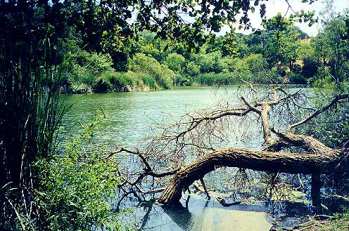
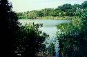
 Trees and reeds block your view of the lake except for a few clear spots.
One clear spot is near the southeast corner of the lake.
Trees and reeds block your view of the lake except for a few clear spots.
One clear spot is near the southeast corner of the lake.
Here are some more pictures of Arastradero Lake:
 At 0.68 miles, an old paved road goes uphill to Paseo Del Roble at the
park boundary. A narrow dirt trail turns right to follow along the lake
bank. Follow this trail through the trees. At 0.71 miles, there is a small
beach on the side of the lake lined with reeds. There is a trail that continues
around the lake, but at the time I went, it was closed, so I had to turn
back.
At 0.68 miles, an old paved road goes uphill to Paseo Del Roble at the
park boundary. A narrow dirt trail turns right to follow along the lake
bank. Follow this trail through the trees. At 0.71 miles, there is a small
beach on the side of the lake lined with reeds. There is a trail that continues
around the lake, but at the time I went, it was closed, so I had to turn
back.
 Heading back around the lake, cross back over the bridge and continue to
follow the lake around to the left. At 0.87 miles, you reach a large trail
junction by a pumping station. A wide dirt service road goes uphill to
the right and eventually ends at park gate B on Arastradero Road.
Heading back around the lake, cross back over the bridge and continue to
follow the lake around to the left. At 0.87 miles, you reach a large trail
junction by a pumping station. A wide dirt service road goes uphill to
the right and eventually ends at park gate B on Arastradero Road.
 The Corte Madera Trail continues to follow the lake to the left. A few
gaps in the trees provide views of and sometimes access to the lakeshore.
Soon the road reaches the end of the lake and continues to follow along
the creek At 0.93, a trail leads to the left to reach the creek and circle
behind the lake. This trail was closed.
The Corte Madera Trail continues to follow the lake to the left. A few
gaps in the trees provide views of and sometimes access to the lakeshore.
Soon the road reaches the end of the lake and continues to follow along
the creek At 0.93, a trail leads to the left to reach the creek and circle
behind the lake. This trail was closed.
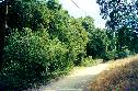 The Corte Madera Trail continues to follow along the creek. The trail is
wide and shady, with dense growth along the creek. The trees are mostly
oak and the underbrush is mostly wild blackberries and poison oak. Spanish
moss drapes from the oak trees. At 1.08 miles, the trail turns to the right
and goes uphill. It levels off at around 1.13 miles. From here, the green
manicured hills of the golf course can be seen above the trees to the right.
At 1.28 miles on the right is the closed end of the old lower Acorn Trail.
Dense vegetation blocks views of the creek to the left. The trail again
begins to climb uphill to the right.
The Corte Madera Trail continues to follow along the creek. The trail is
wide and shady, with dense growth along the creek. The trees are mostly
oak and the underbrush is mostly wild blackberries and poison oak. Spanish
moss drapes from the oak trees. At 1.08 miles, the trail turns to the right
and goes uphill. It levels off at around 1.13 miles. From here, the green
manicured hills of the golf course can be seen above the trees to the right.
At 1.28 miles on the right is the closed end of the old lower Acorn Trail.
Dense vegetation blocks views of the creek to the left. The trail again
begins to climb uphill to the right.
 At 1.46 miles, the new lower Acorn Trail goes uphill to the right as a
narrow single-track.
At 1.46 miles, the new lower Acorn Trail goes uphill to the right as a
narrow single-track.
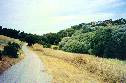 Continuing on the wide gravel road of the Corte Madera Trail, large expensive
houses come into view on the hilltops to the left. There is a meadow between
the trail and the trees lining the creek below to the left. At 1.49 miles,
the trail crests, drops a little, rises, then levels off again.
Continuing on the wide gravel road of the Corte Madera Trail, large expensive
houses come into view on the hilltops to the left. There is a meadow between
the trail and the trees lining the creek below to the left. At 1.49 miles,
the trail crests, drops a little, rises, then levels off again.
 At 1.63 miles, a new trail runs uphill to the right. Trees and brush run
closer to the trail as the creek approaches it. At 1.69, the upper Acorn
Trail climbs steeply up the hill to the right. We'll go up this trail later.
At 1.63 miles, a new trail runs uphill to the right. Trees and brush run
closer to the trail as the creek approaches it. At 1.69, the upper Acorn
Trail climbs steeply up the hill to the right. We'll go up this trail later.
 On the left, a small pond can be glimpsed through the bushes to the left.
At 1.72, a small path leads to the pond. This is Sobey Pond. It is a shallow
pond formed by an earthern dam on Arastradero Creek.
On the left, a small pond can be glimpsed through the bushes to the left.
At 1.72, a small path leads to the pond. This is Sobey Pond. It is a shallow
pond formed by an earthern dam on Arastradero Creek.
 Tall reeds grow in the marsh area on the upstream side of the pond.
 Continuing on the main trail, a sign ahead warns that the utility road
ends in 0.6 miles and that there is no access to Foothills Park. The creek
begins to run through a narrow canyon. The creek above Sobey Pond is not
much more than a ditch.
Continuing on the main trail, a sign ahead warns that the utility road
ends in 0.6 miles and that there is no access to Foothills Park. The creek
begins to run through a narrow canyon. The creek above Sobey Pond is not
much more than a ditch.
 The road runs through a shady oak and laurel forest.
 The deep, cool shade allows ferns to grown on the hillsides. The road begins
to climb uphill.
The deep, cool shade allows ferns to grown on the hillsides. The road begins
to climb uphill.
 The creek runs alongside the trail in a narrow, deep trough at the base
of a steep-sided hill. It is shaded by laurels and buckeyes.
The creek runs alongside the trail in a narrow, deep trough at the base
of a steep-sided hill. It is shaded by laurels and buckeyes.
 At 2.15 miles is the closed gate and overgrown road to Foohills Park. The
creek continues on to its origin in the hills of Foothills Park.
At 2.15 miles is the closed gate and overgrown road to Foohills Park. The
creek continues on to its origin in the hills of Foothills Park.
 The road turns to the right away from the creek and climbs steeply upward.
The hills become dryer, with coyote bushes growing on the upper slopes.
At 2.34, at the summit of the hill, a paved private road runs off to the
right. A barbed wire fence on the left marks the Foothills Park boundary.
The road turns to the right away from the creek and climbs steeply upward.
The hills become dryer, with coyote bushes growing on the upper slopes.
At 2.34, at the summit of the hill, a paved private road runs off to the
right. A barbed wire fence on the left marks the Foothills Park boundary.
 The road then drops steeply downhill ahead, but is blocked at the end by
a gate. A sign on the gate, which is the Foothills Park boundary, says
that no entry is allowed ahead. Since it is a dead end, there is no use
continuing on, so head back.
The road then drops steeply downhill ahead, but is blocked at the end by
a gate. A sign on the gate, which is the Foothills Park boundary, says
that no entry is allowed ahead. Since it is a dead end, there is no use
continuing on, so head back.
 Coming back along the trail, at 2.98 miles, you reach the start of the
upper Acorn Trail.
Coming back along the trail, at 2.98 miles, you reach the start of the
upper Acorn Trail.
 The first part runs through an oak forest, then climbs steeply through
open grasslands.
The first part runs through an oak forest, then climbs steeply through
open grasslands.
 As you ascend the hill, more of the surrounding hills come into view. You
can see the houses on the hills on the east side of the park.
As you ascend the hill, more of the surrounding hills come into view. You
can see the houses on the hills on the east side of the park.
 Looking to the southeast, you can see the Arastradero Creek watershed and
the hills of Foothills Park.
Looking to the southeast, you can see the Arastradero Creek watershed and
the hills of Foothills Park.
 At 3.08 miles, the trail forks as it runs on both sides of an old oak tree
near the top of the hill. The trails rejoin past the oak tree. On the hill
are oak plantings. Black plastic on the ground marks a restoration project.
The plastic is used to heat up the ground in an effort to control the non-native
invasive teasels.
At 3.08 miles, the trail forks as it runs on both sides of an old oak tree
near the top of the hill. The trails rejoin past the oak tree. On the hill
are oak plantings. Black plastic on the ground marks a restoration project.
The plastic is used to heat up the ground in an effort to control the non-native
invasive teasels.
 At this altitude, you can see over the nearby hills and catch views of
the Bay and Bayshore.
At this altitude, you can see over the nearby hills and catch views of
the Bay and Bayshore.
 At 3.16 miles, you reach a trail junction. To the left, the trail is a
narrow path lined with tall grass and (ouch!) prickly yellow starthistles.
On the right, a wide gravel service road, the Meadowlark Trail, can be
seen. Take a side trip to the right and go down this gravel road to the
right.
At 3.16 miles, you reach a trail junction. To the left, the trail is a
narrow path lined with tall grass and (ouch!) prickly yellow starthistles.
On the right, a wide gravel service road, the Meadowlark Trail, can be
seen. Take a side trip to the right and go down this gravel road to the
right.
 At 3.47 miles, it reaches the junction of the lower Acorn Trail, which
comes up the hill on the right. The road continues downhill. However, turn
around and backtrack along the gravel road.
At 3.47 miles, it reaches the junction of the lower Acorn Trail, which
comes up the hill on the right. The road continues downhill. However, turn
around and backtrack along the gravel road.
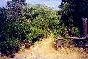
 At 3.49 miles, a trail leads off to the right. Along it is a picnic table
and a rack for tying up horses. Take this side trail.
At 3.49 miles, a trail leads off to the right. Along it is a picnic table
and a rack for tying up horses. Take this side trail.
 It runs uphill and ends at the top of a hill at 3.58 miles at a bench under
a lone oak tree. A sign says "Aladdin's View." The view from this point
is one of the best in the preserve. A good portion of the Bay Area is visible.You
can see the skyscrapers of San Francisco to the north and the buildings
of downtown San Jose to the south. Closer in, you can see downtown Palo
Alto, and the Stanford Hills. Here are some views from the hill:
It runs uphill and ends at the top of a hill at 3.58 miles at a bench under
a lone oak tree. A sign says "Aladdin's View." The view from this point
is one of the best in the preserve. A good portion of the Bay Area is visible.You
can see the skyscrapers of San Francisco to the north and the buildings
of downtown San Jose to the south. Closer in, you can see downtown Palo
Alto, and the Stanford Hills. Here are some views from the hill:
The trail dead ends here, so after taking in the view, head back to
the gravel service road, which you reach at 3.68 miles. Head back to the
Acorn Trail junction, which you read at 3.78 miles. Take the trail back
to the left.
  After 3.81 miles, you reach the Acorn Trail T-junction again. Continue
on to take the loop to the west. It climbs up to the park boundary at 3.90
miles, then turns right, paralleling the boundary fence. At 3.98 miles,
it reaches another T-junction. The path to the left goes uphill into the
woods, but it crosses into private property, so don't take it.
After 3.81 miles, you reach the Acorn Trail T-junction again. Continue
on to take the loop to the west. It climbs up to the park boundary at 3.90
miles, then turns right, paralleling the boundary fence. At 3.98 miles,
it reaches another T-junction. The path to the left goes uphill into the
woods, but it crosses into private property, so don't take it.
 From here the trails and hills to the north can be seen.
 Turn right. The trail drops down steeply, then goes up again. At 4.05 miles,
it reaches a junction. To the right is a short path to the gravel service
road. Take the path to the left.
Turn right. The trail drops down steeply, then goes up again. At 4.05 miles,
it reaches a junction. To the right is a short path to the gravel service
road. Take the path to the left.
 At 4.09 miles, it comes to a flat open area with paths through it and around
it. Take the trail around it to the right. It climbs slightly, drops downhill,
then begins to climb uphill.
At 4.09 miles, it comes to a flat open area with paths through it and around
it. Take the trail around it to the right. It climbs slightly, drops downhill,
then begins to climb uphill.
 This is a view from the hill, looking back down the trail to the hills
west of the park.
This is a view from the hill, looking back down the trail to the hills
west of the park.
 From the hill, the Meadowlark Trail can be seen on the right. At 4.26 miles,
you reach the crest of the hill. The view to the north shows houses in
the foothills of the Santa Cruz Mountains.
From the hill, the Meadowlark Trail can be seen on the right. At 4.26 miles,
you reach the crest of the hill. The view to the north shows houses in
the foothills of the Santa Cruz Mountains.
 At 4.30 miles, you reach a crossroads. Straight ahead, the trail drops
down into a steep-sided bowl, obviously a favorite spot for bikes. You
can drop into the bowl and have fun riding up and down its sides. There
is a path on the far side of the bowl. Otherwise, turn right. At 4.32 miles,
under a big oak tree, you reach a trail junction. A trail leads uphill
to the right. A trail sign points to the left. Take the trail to the left.
From here, you can see the Stanford Hills ahead. The trail runs along the
east edge of the bowl and rejoins the trail on the north edge of the bowl
at 4.35 miles.
At 4.30 miles, you reach a crossroads. Straight ahead, the trail drops
down into a steep-sided bowl, obviously a favorite spot for bikes. You
can drop into the bowl and have fun riding up and down its sides. There
is a path on the far side of the bowl. Otherwise, turn right. At 4.32 miles,
under a big oak tree, you reach a trail junction. A trail leads uphill
to the right. A trail sign points to the left. Take the trail to the left.
From here, you can see the Stanford Hills ahead. The trail runs along the
east edge of the bowl and rejoins the trail on the north edge of the bowl
at 4.35 miles.
 It turns to the right and heads downhill to join the gravel service road.
Follow the service road to the left.
It turns to the right and heads downhill to join the gravel service road.
Follow the service road to the left.
 At 4.56 miles, it reaches a trail junction at a large oak tree. A bench
provides a place to rest. The gravel service road exits the preserve at
Gate C at John Marthen Lane, which leads to Arastradero Road near Alpine
Road. The trail to the right is the lower Acorn Trail. Take it. It becomes
a double-track dirt trail. It runs across a field, then drops downhill
into a gully at 4.77 miles. A small creek runs to the right through here,
marked by oaks and coyote bushes. The trail goes up a small hill, where
it meets the junction of the Perimeter Trail, which branches off to the
left. Bicycles are not allowed on the narrow Perimeter Trail. Continue
to the right.
At 4.56 miles, it reaches a trail junction at a large oak tree. A bench
provides a place to rest. The gravel service road exits the preserve at
Gate C at John Marthen Lane, which leads to Arastradero Road near Alpine
Road. The trail to the right is the lower Acorn Trail. Take it. It becomes
a double-track dirt trail. It runs across a field, then drops downhill
into a gully at 4.77 miles. A small creek runs to the right through here,
marked by oaks and coyote bushes. The trail goes up a small hill, where
it meets the junction of the Perimeter Trail, which branches off to the
left. Bicycles are not allowed on the narrow Perimeter Trail. Continue
to the right.
 The trail drops down to meet a wide gravel service road at 4.82 miles.
To the right, it becomes a paved road just past a bridge over the creek.
Do not take this paved road, because it is just a dead end service road
to a water tank. Past the bridge, the dirt Acorn Trail continues on, following
the far side of the creek. However, for this trip, turn left and follow
the gravel service road. At 4.94 miles, it crosses the creek. A dirt footpath
goes up to the left to provide access to the Perimeter Trail.
The trail drops down to meet a wide gravel service road at 4.82 miles.
To the right, it becomes a paved road just past a bridge over the creek.
Do not take this paved road, because it is just a dead end service road
to a water tank. Past the bridge, the dirt Acorn Trail continues on, following
the far side of the creek. However, for this trip, turn left and follow
the gravel service road. At 4.94 miles, it crosses the creek. A dirt footpath
goes up to the left to provide access to the Perimeter Trail.
 Even though the creek is likely to be dry, it has a lot of vegetation growing
along it. This is a shady route. At 5.09 miles, the road turns right and
goes uphill. At the corner, a foothpath leads through the bushes to the
Perimeter Trail. The service road now parallels Arastradero Road, which
runs just above it to the left.
Even though the creek is likely to be dry, it has a lot of vegetation growing
along it. This is a shady route. At 5.09 miles, the road turns right and
goes uphill. At the corner, a foothpath leads through the bushes to the
Perimeter Trail. The service road now parallels Arastradero Road, which
runs just above it to the left.
 At 5.20 miles, it reaches Gate B on Arastradero Road.
 At the gate, the Perimeter Trail (no bicycles) follows along the perimeter
fence of the reserve next to Arastradero Road.
At the gate, the Perimeter Trail (no bicycles) follows along the perimeter
fence of the reserve next to Arastradero Road.
 Follow the service road to the right. It runs around a field to left that
may be covered with teasels. At 5.31 miles, a dirt trail goes up and over
a hill to the left. The main trail continues on to the right, then passes
through an area of broad, wide-open rolling meadows.
Follow the service road to the right. It runs around a field to left that
may be covered with teasels. At 5.31 miles, a dirt trail goes up and over
a hill to the left. The main trail continues on to the right, then passes
through an area of broad, wide-open rolling meadows.
 Ahead, the golf course can be seen on the upper hills.
At 5.39 miles, it reaches the junction with the Meadowlark Trail.
The service road continues on to the south end of Arastradero Lake, where
it meets the Corte Madera Trail (see the 0.87 mile point above).
 The Meadowlark Trail runs up the hills to the right to where it meets the
junction of the gravel service road and the Acorn Trail, seen at 3.47 miles.
The Meadowlark Trail runs up the hills to the right to where it meets the
junction of the gravel service road and the Acorn Trail, seen at 3.47 miles.
 Take the Meadowlark Trail to the left.
 It is a dirt double-track that runs along the side of hill. Below the trail
on the right, you can see Arastradero Lake, with the golf course on the
hills behind it.
It is a dirt double-track that runs along the side of hill. Below the trail
on the right, you can see Arastradero Lake, with the golf course on the
hills behind it.
 At 5.57 miles, the trail drops down. You can see the hills of the preserve
east of Arastradero Road. The trail curves to the right. You can see Arastradero
Road and the stables up the road to the left. At 5.82 miles, you reach
the junction of the Perimeter Trail, which comes from the left. An unmarked
dirt trail continues on straight ahead.
At 5.57 miles, the trail drops down. You can see the hills of the preserve
east of Arastradero Road. The trail curves to the right. You can see Arastradero
Road and the stables up the road to the left. At 5.82 miles, you reach
the junction of the Perimeter Trail, which comes from the left. An unmarked
dirt trail continues on straight ahead.
 The Meadowlark Trail makes a sharp right turn and drops quickly down the
hill. At 5.90 miles, it reaches the Corte Madera Trail. An unmarked dirt
trail runs along the north side of Aratstradero Creek. Turn left at the
Corte Madera Trail and follow it back to the preserve entrance.
The Meadowlark Trail makes a sharp right turn and drops quickly down the
hill. At 5.90 miles, it reaches the Corte Madera Trail. An unmarked dirt
trail runs along the north side of Aratstradero Creek. Turn left at the
Corte Madera Trail and follow it back to the preserve entrance.
Cross Arastradero Road and head back to the parking lot, which you reach
at 6.15 miles. If you like, you can explore the hills to the east of the
parking lot. These rolling grass-covered hills adjoin Stanford's pasture
lands. The trails provide views of Hwy 280, Felt Lake, and the Stanford
antenna dishes and hills. A line of eucalyptus trees runs along the eastern
boundary of the preserve. Felt Lake, which is off-limits, is just beyond
the northeast corner. Looking back to the west, most of the rest of the
park can be seen below the Santa Cruz Mountains. Below are pictures from
this section:
 A gap in the parking lot fence allows access to the hills.One trail leads
up the hill to the right.
A gap in the parking lot fence allows access to the hills.One trail leads
up the hill to the right.
 On the way up the hill, looking back, the parking lot, the private inholding
across from it, and the park hills can be seen.
On the way up the hill, looking back, the parking lot, the private inholding
across from it, and the park hills can be seen.
 From the top of the hill, the park entrance can be seen below to the left,
with the golf course in the hills above it.
From the top of the hill, the park entrance can be seen below to the left,
with the golf course in the hills above it.
 From the hilltop, the parking lot and the rest of the preserve can be seen
below and to the west.
From the hilltop, the parking lot and the rest of the preserve can be seen
below and to the west.
 A trail leads down from the hills and runs parallel to the fence on the
preserve's eastern border.
A trail leads down from the hills and runs parallel to the fence on the
preserve's eastern border.
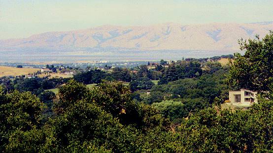
 Looking beyond the eastern border, Stanford's open space lands and Hwy
280 can be seen. A small forest runs in a valley from the park boundary
to Hwy 280.
Looking beyond the eastern border, Stanford's open space lands and Hwy
280 can be seen. A small forest runs in a valley from the park boundary
to Hwy 280.
 A line of eucalyptus trees lines the fence along the preserve boundary.
 Beyond the fence, Felt Lake can be seen. The lake is part of the San
Francisquito Creek watershed. It is an artificial reservoir created
in 1929 when Stanford University built a diversion dam on Los Trancos
Creek. Felt Lake is part of Stanford's
nonpotable water supply. Water is used for irrigation and fire protection.
In 1995, a fish
ladder was built to allow steelhead trout to migrate upstream past
the dam. The lake, like the surrounding lands, is a biological preserve
and off-limits to unauthorized personnel.
Beyond the fence, Felt Lake can be seen. The lake is part of the San
Francisquito Creek watershed. It is an artificial reservoir created
in 1929 when Stanford University built a diversion dam on Los Trancos
Creek. Felt Lake is part of Stanford's
nonpotable water supply. Water is used for irrigation and fire protection.
In 1995, a fish
ladder was built to allow steelhead trout to migrate upstream past
the dam. The lake, like the surrounding lands, is a biological preserve
and off-limits to unauthorized personnel.
 A trail leads down from the middle of the hills back to the parking lot.
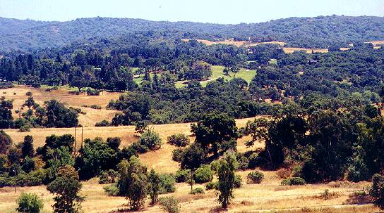
 Looking back at the main part of the preserve from this middle trail, the
path of Arastradero Creek can be seen, marked by trees. In the hills above
are trails running along the park boundary below the golf course.
Looking back at the main part of the preserve from this middle trail, the
path of Arastradero Creek can be seen, marked by trees. In the hills above
are trails running along the park boundary below the golf course.
 This view shows the golf course in the hills above the preserve and the
Santa Cruz Mountains beyond that.
This view shows the golf course in the hills above the preserve and the
Santa Cruz Mountains beyond that.
Links:

Created 7/3/01 by
Ronald Horii
|